Sunday, April 7, 2013

April 7

Today was dreary grey, started with some rain which tapered off in the afternoon.

Temperature: 41°F
Dewpoint: 34°F
Humidity: 78%
Wind: 0 mph
Pressure: 1012.3 mb
Wow, not sure what to make of this, it looks like a map of how to get from BC to Quebec through the United States. Looks like that continental polar airmass is still moving through, but we have some low pressure systems making their way to us. Possibly an Alberta Clipper and a Colorado Low on the way over here. There will probably be some thunderstorms in the mid states. For us, we can expect rain or light snow in the next few days.
 

Here is the sky at about 4:30pm, we have some cirrus and cumulus clouds, possibly indicating more rain to come.

Saturday, April 6, 2013

April 6

Today started out decent, but at the moment it is raining and the sky is overcast. Looks like we were impacted by that weather system as was predicted.

Temperature: 37°F
Dewpoint: 36°F
Humidity: 96%
Wind: NW at 14mph
Pressure: 999.7mb

 So, here is our surface weather map. As you can see we have a low pressure system dominating our region. That cold continental polar airmass that we saw previously has mixed with the warm maritime tropical airmass that followed the jetstream up from the south east.
 Here is the current jetstream image.
 There is a lot of moisture in the air, as we can see by this water vapor satellite image. Plenty of moisture in our area, as well as near the Rockies.
 You can see the low pressure system pulling the air into itself over us, causing rain and poor weather.

Judging by this trend, I would suggest that we will continue to receive bad weather tomorrow, there might be a break between the low pressure systems over us and the ones over Texas and Oklahoma, but I'd like to predict that we will be hit by those also in the coming days, causing more precipitation, possibly in the form of snow or cold rain as that air mixes with the polar airmass.

April 5

I didn't do much weather watching today because I was on a field trip to Minneapolis. Saw some cool clouds, which I will post in a bit here. Also, I observed the weather going from cold (27°F - 7am) to warm (42°F - 12pm). In the morning I observed some cirrus clouds and a relatively clear sky in the morning, which evolved into an overcast sky and snow by early afternoon.
 

Thursday, April 4, 2013

April 4 Red sky in morning...

Today was chilly, as of this time no precipitation. (yay)

Temperature: 39°F
Dewpoint: 28°F
Humidity: 64%
Pressure: 1016.7 mb
Wind: 5mph W

 Here is a photo from this morning around 7am, you can see a slight red tint, which brings about the old folk saying that I grew up - "Red sky in morning, sailors take warning". I think we are seeing some instability in the atmosphere, especially with the cloud cover. We have some Stratus clouds, along with some altocirrus clouds.

 Here we can see another continental polar air mass making its way down across the United states. The tip of the cold front is just approaching Wisconsin. The low to the west will make its way east, and its cold air will mix with the warm air coming from the southern tropical jetstream, creating precipitation for us, possibly light snow or rain.
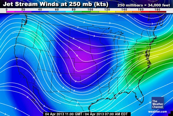
 Here you can see a unisys 500 mb map. This height in mb is great to look at because it is not at the surface level, and not too high in the atmosphere that we can see patterns in weather. This picture combined with the jetstream image below, paints a clear picture of the weather patterns. We can see a distinct trough in the mid states Nebraska and Kansas. It almost looks like the low pressure system has moved a little east already, we may get precipitation tomorrow, however there is a possibility that the lower half of Wisconsin will be affected, and we may have cloud cover and colder temperatures instead.

Here is the water vapor map, you can see a possible cyclone developing by the gulf of mexico.

Wednesday, April 3, 2013

April 3

Today is nice as well, still pretty chilly.

Temperature: 41°F
Dewpoint: 12°F
Humidity: 31%
Wind: 8mph SSW
Pressure: 1029.8 mb

 The high pressure system is still remaining in our area, there is a low system, possibly a maritime polar air mass moving around in north west. The continental polar airmass that moved down to the south is now mixing with the maritime tropical airmass by the gulf of mexico, and now is creating thunderstorms.
 Plenty of moisture in the air to the south, and north of us.

April 2

Yesterday's Weather:

Temperature: 17 F
Dewpoint: 9 F
Humidity: 70%
Wind: 3mph WSW
Pressure: 1024.7 mb

It was pretty nice on Tuesday. The continental polar airmass can still be seen moving south, giving us a high pressure system and nice weather.

Monday, April 1, 2013

April 1

The storm siren went off today, but I think it was a joke.

Today was nice, no precipitation... it was chilly though.

Temperature: 25 F
Dewpoint: 15 F
Humidity: 66%
Pressure: 1023.4 mb
Wind: 5 mph WNW

Looks like the high pressure systems are still in our area. The southwest region of the states has a lot of moisture and low pressure systems, which may sweep over to the east coast. I'm not sure how that will affect us in Wisconsin, I think that the high pressure will remain for the next day or so.