Temperature: 27.9°F
Dewpoint: 16°F
Wind: 3.8mph from ENE
Humidity: 61%
Pressure: 30.01"
So far, it is nice outside right now. Much chillier than yesterday but as of 1pm it was nice outside, I may post again briefly later to see how it adjusts. (2:06pm, it is lightly snowing outside).

Here is the surface map with my interpretation of it. We have two low pressure systems working together moving to the east. The warm air from the south is mixing, there was a lot of moisture in the NW that is also contributing to this storm.
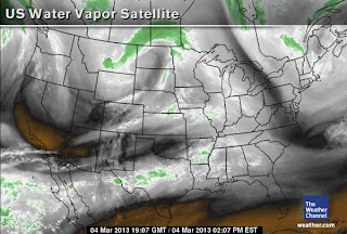
This satellite image shows the water vapor in the air, the green indicates a large mass of moisture.
Here is a snowfall prediction map from accuweather.com. It is possible that Eau Claire may recieve anywhere from 3-12 inches tonight.
Here is a Skew-t Diagram for Minneapolis, it represents a weather balloon sounding information. The white line on the right represents temperature, the white line on the left represents dewpoint. When those two solid white lines connect that indicates precipitation. Therefore in minneapolis it is probably snowing.


No comments:
Post a Comment