Thursday, February 28, 2013

Feb 28

It snowed a bit today and was cold. Cloud cover earlier today was overcast mostly.

Info as of 7:00pm:

Temperature: 26°F
Dewpoint: 19°F
Humidity: 77%
Pressure: 30.15"
Wind: 6mph E NE

 Surface map indicates a air mass moving down from the north, we may have a low pressure system interfere in the next few days from the west.
 You can see moisture in the air over Minnesota from the Water Vapor satellite image.
Jetstream still shows the low pressure system we talked about previously, moving to the east.

Wednesday, February 27, 2013

Feb 27

It is 2pm, there was a light snow outside, but the temperature felt decent.

Temperature: 34°F
Dewpoint: 26°F
Wind: 1.6mph NE
Humidity: 75%
Pressure: 29.79"
Surface map shows that the Low pressure system is moving along to the east. I believe the light snow we recieved is due to that storm, but it should die out. There appears to be a cold front over Ontario, that may make its way to us, along with a Low system by the rockies in Alberta. The alberta low may move along the polar jetstream and eventually end up here.
 You can see the effects of the low pressure system in the jetstream. Possibly may cause issues for the east coast.
 You can see the deep divide in moisture along the east coast, along with the buildup of moisture on the west coast. I predict that those systems will affect us.


Feb 26

Temperature: 32F
Dewpoint: 35F
Wind: 1.6 mph from E
Humidity: 74%
Pressure: 29.84 in

Today was nice, no rain or snow, mild temperatures.
 We have some interesting low pressure systems near Wisconsin. Unfortunately it looks like we may develop some moisture in the air, although the low to the south of us is on an occluded front, hopefully it will die out soon. I am more concerned with the Low to the north, I am confused at this point as to what that might bring us.

 Here is a water vapor image, it shows the low pressure system very well. You can see there is water vapor prevalent over Wisconsin.
Here is the jetstream forcast for Wednesday. It looks really funky, I believe that this is evidence that the low to the north will come our way.

Monday, February 25, 2013

Feb 25

Temperature: 36°F
Dewpoint: 29°F
Wind: 1mph W
Humidity: 75%
Pressure: 30.06 in

It was lightly snowing outside, barely noticeable, overcast skies. Was not cold enough to wear gloves, which was nice.

Weather.com images:
Surface map, it looks as if that low we talked about yesterday is moving along. Currently over Wisconsin there is no pressure systems. We may be influenced by the system over the NW region in a few days, which may come across along the jetstream.

 The jetstream image for tomorrow, Tuesday. There is a deep trough in the mid states, influencing that low pressure system over Texas. That may bring the moisture up our way.
 Here is a look at the weather stations, from weather.unisys.com, the weather station near Eau Claire indicates no wind and overcast skies. This image also indicates that wind is being directed south to the west, feeding that low system to the south.
Here is a weather.com water vapor satellite image. you can see the low system in the south, as well as a buildup of moisture in the North West.

Sunday, February 24, 2013

Feb 24

Temperature: 38°F (yay!)
Dewpoint: 22°F
Wind: 3mph W
Pressure: 30.06"
Humidity: 55%
 
Cloud cover is partly cloudy, looks overcast but its nice and bright.
 
Weather.com map:
 
 Currently there are high pressures systems in our area, possibly accounting for the lack of snow. There are two low pressure systems over texas, which may follow the jetstream to our area or south of us. Possibly bringing more snow monday or tuesday.

Jetstream image from weather.com:
It looks pretty funky. I doubt that it is a coincidence that the low pressure systems are where that odd dip is. 
weather.unisys.com map:
 Weather.com water vapor image:
Some moisture buildup in the middle of the states, which may move our way.

Friday, February 22, 2013

Feb 22 Q

I wish Q was like in star trek, funny and randomly appearing and disappearing. But storm Q is not funny, and not random, we saw it coming.

It is still snowing at 12:23pm, big flakes with overcast skies.

Temperature: 26 F
Dewpoint: 24 F
Wind: 5mph E
Humidity: 94%
Pressure: 29.84 in and dropping

There is a winter weather advisory predicting snow until 6pm.

weather.com surface map:
You can see an occluded front over south Wisconsin, hopefully showing that winter storm Q will lose steam and die out. However the occlusion of warm and cold front may create more precipitation.
 
The jetstream indicates that some high pressure systems may move into our area by tomorrow coming up from oklahoma to the wisconsin area.

you can see that our area has a low pressure system by the wind direction and cloud cover. also, the yellow asterix over the mid weather stations in Wisconsin indicate moderate snow currently occuring.

Hopefully tomorrow we will see better weather.


Thursday, February 21, 2013

Feb 21

Learning about weather is suspensful! apparently we have a big storm moving up this way, and I'm torn between wanting to see it come and not wanting to have snow.

Anyway,

here are today's stats:

Temperature: 20°F
Dewpoint: 12°F
Wind:1.6mph from the ESE
Humidity: 72%
Pressure: 30.18" and dropping (drop in pressure indicates that bad weather may be approaching)

Here is todays weather.com surface map: 
There are several low pressure systems to the south, they are gathering moisture and momentum from the tropical jetstream. You can see the moisture building up on the radar, causing snow in some of the middle northern states.
 
Also from weather.com this water vapor satellite image shows the buildup of water vapor (green area) over the states, we can see the storm system moving in.
 
Finally the jetstram image from intellicast. This clearly shows the jetstream pushing that moist air. you can see how the cold air from the north is mixing with the warmer air from the south creating the winter storm Q.
 
It looks like there is a chance Wisconsin will get hit by the tail of this storm, causing snow; but the majority of the storm should hit the states to the south of Wisconsin, which lie in the path of the jetstream. I predict warmer temperatures and snow tomorrow.


Wednesday, February 20, 2013

Feb 19

Temperature: 19.4°F
Dewpoint: 6°F
Wind: 1.6 mph from WSW
Humidity: 55%
Pressure: 30.40 in

Today's weather.com surface map:US: Current Weather
There is a bunch of low pressure systems by the rockies on the west coast that may travel along the jet stream and over to our area. I expect that we shall see some precipitation and snow tomorrow.
 
NAM_MOS - MW - 12hr
We can see low temperature in the wisconsin area, clear and also overcast cloud cover.
 
Wednesday US Jet Stream
The jetstream is really wack. You can see there is a ridge over wisconsin, creating possible high winds and moving those low pressure systems and precipitation our way.

Monday, February 18, 2013

Feb 18

Today's information:
Temperature: 40.6°F
Dewpoint: 29°F
Wind: Calm
Humidity: 65%
Pressure: 29.51 in

Here is our weather.com surface map for today:

US: Current Weather
There is a lovely low pressure system over the north of wisconsin at the moment, possibly traveled there yesterday through the jetstream. You can see an occluded front, which is a warm and cold front overlapping, and a moving cold and warm front. This explains our warm temperatures, and I predict that we may recieve snow soon.
 
Here is tomorrow's jetstream forecast:
 
Tuesday US Jet Stream
Looks like that low pressure system will move on to the east, and we may get colder temperatures from the north.
 
weather.unisys.com map: 
Surface Data - Midwest Current

Sunday, February 17, 2013

Feb 17

It is a beautiful day out today, skies are clear, now snow or rain!
 
 
Today's information:
Temperature: 22°F
Dewpoint: 9°F
Wind: 7mph S
Humidity: 59%
Pressure: 30.02 in
 
Here is today's weather.com surface map:
 
You can see a warm front which will move clockwise around that high pressure system to the south east of Wisconsin, hopefully following the jetstream and bringing us warmer temperatures. However there is a low pressure system to north west, which may bring that cold front over to us also.
 
Here is the jetstream image for today from weather.com:
You can see the path of the jetstream and how it may impact Wisconsin due to the ridge(?) of air moving past us.
Unisys surface model station map:
 This image just shows how the jetstream is moving, you can see the bars on the circles pointing in the same directions. Also over Wisconsin, you can see it is clear skies, and light to moderate winds.

Saturday, February 16, 2013

Feb 16

Its a nice clear day out, there is some cloud cover, but I can see blue skies!


Today's Stats:
 
Temperature: 19.9°F
Dewpoint: 6°F
Wind: 2.2 mph from SSW
Humidity: 56%
Pressure:
 
Here is today's weather.com surface map:
 
There are two stationary fronts in our area, thankfully no low pressure systems. I expect that we will have higher pressure in the area, leading to calmer skies, and hopefully warmer temperatures in the days to come.


Unisys weather station model map:
you can see evidence of the stationary fronts by the overcast (filled white circles) over the Dakotas and the wind there is coming from the South. Over wisconsin, the wind is coming from the North West, and there is evidence of calm and clear skies.

Friday, February 15, 2013

Feb 15 I'm glad I don't live in Chelyabinsk, Russia.

Yesterday was so busy! That cold front I mentioned on Wednesday came through and dropped a few good inches of snow on us... at least it wasn't a meteor (which I think was really awesome by the way, minus the people getting hurt, and buildings being destroyed)

Today's stats as of 9:10pm:

Temperature: 12.2°F
Dewpoint: 2°F
Wind: .7 mph from the WNW
Humidity: 62%
Pressure: 30.23in

Here is the jetstream image from intellicast:
 
  
Look at that trough, I think thats a trough going through Minnesota, there are some decent winds following jetstream.
Here is today's surface map from weather.com:
 
 There are plenty of High pressure systems over the mid states, along with the jetstream I believe that we may get wind tomorrow and possibly clear skies.
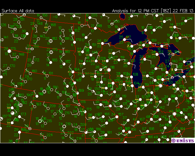
 Here is the unisys weather station model:
 There are some overcast areas in the north of Wisconsin, but going through Minnesota and Iowa (I think) there are clear skies, which is not surprising following the jetstream.

I predict that tomorrow will bring clear skies and possibly cold temperatures due to the jetstream moving through.


Wednesday, February 13, 2013

Feb 13

Temperature: 40.3°F
Dewpoint: 27°F
Wind: Calm
Humidity: 58%
Pressure: 29.66

Itellicast Jetstream map for Thursday:
You can see the jet stream is still moving far to the south down the Rockie Mountain range, up to the east coast.
 
If you look at  the weather stations over kansas, missouri etc, you can see that the weather stations indicate clear skies and moderate winds, this shows the path of the jetstream.
 
Here is today's surface map from weather.com:
 You can also see the jetstream moving along here with the highs along the west coast. However in our region, you can see a low pressure system driving a cold front to our area.

Tuesday, February 12, 2013

Feb 12

Today was nice, a little chilly, but I didnt see much snow or rain. The roads were very slushy and slippery though!

Today's weather stats:

Temperature: 28.6°F
Dewpoint: 22°F
Wind: Calm
Humidity: 78%
Pressure: 29.84 in

Here is our weather.com surface map:


There is another warm front moving over wisconsin, hopefully bringing more warm air. The two highs over the eastern continent are promising for clear skies.

Jetstream image for wednesday:

You can see the jetstream is coming down south on the west coast, and will move up to the east coast possibly bringing snow and rain on the east. I am not sure yet if that will cause us issues in wisconsin.
 

Monday, February 11, 2013

Feb 11 More ice and snow

Sorry for not posting yesterday, we had some cool weather (literally, ha) but it was a busy day for me.

Here are today's stats:

Temperature: 23 F
Dewpoint: 17 F
Wind: 3.1 mph from SW
Pressure: 29.99 in
Humidity: 76%

Here is an image of the jetstream forecast for tomorrow: The jetstram will bring cold air down the Rockies and then up to the east coast. This may cause disturbance along the east coast.


Here is our weather.com surface map:
The cold front moving around that low pressure system over quebec may hit us bringing colder temperatures.
US: Current Weather

the unisys surface data map, confirms the air movement to the south east.
Surface Data - Midwest Current Inverted

weather.com's water vapor satelite map:
The dark area shows the movement of the jetstream to the east coast.
US: Water Vapor Satellite

Saturday, February 9, 2013

Feb 9

Another decent day in Eau Claire. I won't complain!

Today's stats as of 6:43pm:
Temperature: 28.6°F
Dewpoint: 24°F
Wind: 2.2 mph ESE
Humidity: 82%

Here is the weather.com surface map, we have a stationary front over wisconsin, and cold front moving around a low pressure system in the south. We will probably see some precipitation as that moisture moves north.


US: Current Weather
Also you can see the storm on the east coast.

Friday, February 8, 2013

Feb 8 In which I'm glad I don't live on the East coast

Its 4pm right now, and its really nice and sunny outside. There is a huge Northeastern storm happening on the East coast right now.

Here are our stats for today:

Temperature: 30.2°F
Dewpoint: 12°F
Wind: 0.7 mph SSE
Humidity: 46%

We had a smidgen of clouds this morning when the sun rose but I didn't really think it was worth it to show, here is a picture I took at about 1pm:

I think those clouds are contrails (lines from a plane passing over). It is a nice blue day.

Here is our weather.com picture, I added some blue arrows to show how the cold air is moving to the south:

As you can see, the nor'easter is hitting the coast now, and will probably bypass us judging by the movement of the pressure system. We might get hit by the edge of it. We will probably have similar temperatures for the next few days, with colder temperature further into next week.